Tuesday 27 September 2011

Snowy mountain

Snowy Mt from route 30

Indian Lake from Snowy Mt
I went for a dayhike to Snowy mountain yesterday. Snowy mountain is just south of the village of Indian Lake, a long drive especially for a day hike but I figured that autumn would be a good time of year to make the longer drive and the colors did not disapoint. Snowy, at 3899 feet is bigger that 4 of the ADK 46 4000 footers and it is certainly tougher than several of them. It is a wooded summit but there are ledges for views east as well as north (be careful not to get too close as there are sharp dropoffs). The show stopper is the fire tower that rises well above the trees.

Bridging across a beaver pond
This hike got off to a bad start and it continued downhill (well, you know what I mean) from there. I got my pack out to find that the bladder had deposited all it's contents on the back seat floor mats. On the plus side I was amazed at how much water the mats had absorbed. So to start I was low on water. To make matters worse it was almost mid summer like yesterday and I starting the hike at 10am in the heat of the day. The trail meanders over mostly flat ground crossing and re-crossing brooks for a few miles. Like with many adirondack hikes, a few miles of flat approach and then all of a sudden straight up.

Fall colors on the shoulder of Snowy Mt
The trail got ever steeper until you climbed out of a steep shute onto a ledge looking east over Indian Lake. I could hear a lot of loud barking from some idiot who had brought cujo up the mountain. The vast majority of dogs that you meet on the trails are friendly but this guy was anything but. To further ruin the usual zen of the mountain summit, there were hordes of deer flies that didn't seem willing to let me take a few photos. I stuck it out for a few minutes to get a few photos before making for the exit. The flies followed me down the trail quite a ways before deciding to let me stop and eat my lunch.

Not the usual relaxing hike but the drive there and back made the day worthwhile.

Labels: , ,

Friday 23 September 2011

Leaves, flowers, shrooms and beavers

I went for walk in Gatineau park today. I started up the steep side of the Wolf trail loop. Hard to believe that there are still biting insects at this time of year. There are occasional patches of color but the full color of fall is still a couple of weeks away.

I saw:

some interesting tree mushrooms

Mushroom on Wolf trail

a turkey vulture from the Wolf trail ridge (excuse the dot on my camera's sensor).

Turkey vulture

some nice flowers along ridge road that the bees were loving

Ridge road flowers

and a beaver pond on ridge road with an active local couple!

Beaver

More beaver shots

Labels: , ,

Friday 16 September 2011

Mt Hight and Carter Dome

Rock "face" from Carter Moriah trail

Damaged bridge across 19 Mile Brook
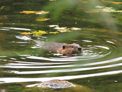
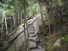
After a day off from the Kinsmans hike to rest my feet, I hiked to Mt Hight and Carter Dome. I went up via Zeta Pass and descended via Carter Notch. This is a beautiful set of trails and the 19 Mile Brook has a healthy amount of water flowing. It was obvious from the start that this is a violent place when the volume of water is high as with hurricane Irene. There was a lot of tree damage along the 19 Mile Brook trail although almost all of it looked pre-Irene. There was plenty of trail erosion in evidence: trail sections gouged to a few feet lower than they were or bank erosion where the trail was directly along the brook. At all water crossings there was some form of bridge although this is due to the excellant work by trail crews as all bridges were damaged or washed away by Irene.

AT hiker leaves the Mt Hight summit
The Carter Dome trail uses switchbacks to lift you up to Zeta pass where there is a bench to take a break. From there and then up the Carter Moriah trail to Mt Hight I met several AT thru hikers approaching from the south. All were raving about the view from Mt Hight (and they were right) and one looked a whole lot like my hiking buddy 
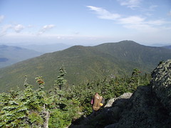
Mark. I had the open summit to myself for about 45 minutes. This is a spectacular spot looking across a valley at Mt Washington and the Northern Presidential range. Great timing for lunch and photography and general spiritual wellness!

Carter Notch from Carter Moriah trail
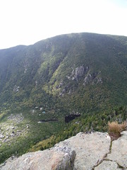
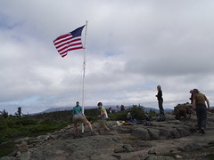
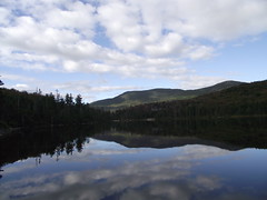
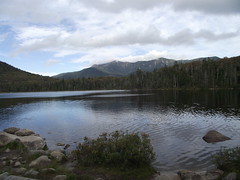
Shortly after setting off for Carter Dome I could hear the first of three groups of high school students. Great to see kids getting to experience the mountains but I was happy to have had the quiet time on Mt Hight. Carter Dome's summit is wooded so I did not stop there and headed down the steep slope to Carter Notch which drops 1500 feet in 1.2 miles. That is very steep although it did not seem so until I reached a lookout with views of the notch and Wildcat ridge. Eventually you reach the hut which has a nice remote feel to it and two small ponds that one could cool off in mid summer. I stopped here for a welcome cup of tea and chatted with the caretaker (it is open off season but you bring your own food), a thru hiker and a woman training a service dog. Having made the steep drop to the hut, the hike out was a gentle grade with the sound of the brook even when you could not see it.

This is a great day hike to do when the forecast calls for clear skies for the view from Mt Hight.

More pics of hike and trail erosion.

Labels: , , , ,

Flags on the Kinsmans

Flags on South Kinsman

Kinsman ridge across Lonesome Lake
Every year since 2002 hikers mark the 9/11 anniversary by installing flags on all the 4000 footers in the WMNF. Since there would be a big turnout this day I opted for a hike with a big parking lot, North and South Kinsman via Lonesome Lake. The switchback trail up to Lonesome Lake is a great warm up. Three long switchbacks lift you 900 feet up to the lake. It doesn't seem that you gained that much but I won't argue with it and it is much easier on the legs at the end of the hike than many trails. There was a steady stream of families with kids coming down from a stay at the Lonseome Lake hut (reputed to be kid friendly). The lake has great views (on clear days) of the Kinsman ridge from the east side of the lake and of Franconia ridge from the west side.

Steps on the Fishing Jimmy trail
From Lonesome Lake I took the Fishing Jimmy trail up to Kinsman ridge. To begin with this trail goes downhill. I was about to turn around and check that I was on the right trail when it abruptly started up and didn't let up for the next hour when it reached Kinsman ridge. I was leap frogging with a few other hikers (hike some and stop to catch your breath). We agreed that the trailwork was quite "civilized". The FJ trail features some wooden steps that are bolted into the rock to get you up some steep rocks slabs. There must have been 30-40 of these steps. In general the trail building in the WMNF is excellant and a pleasure to hike on.

Helicopter saluting the flag on South Kinsman
Both summits have great views to the east of Franconia ridge and beyond. North Kinsman has a small ledge and South Kinsman is flatter and open (this has the better view). I headed for South Kinsman rather than stopping at NK. It was a great place to stop for a while. I chatted for a while with a local who had all sorts of info on hike ideas and trail recommendations. Unfortunately the cloud cover was not great for photography so you will have to take my word for it! Eventually the flag crew arrived and started to set up. The pole was 4-5 pieces of pvc piping which had to be tied to stabilize to support the weight of the flag in the stiff breeze. The crew had obviously done it before and it was nice to see three generations of team members working on their task. A military helicopter flew in from the east and came so close by that you could see the pilot. A similar fly by was done for each peak.

Franconia ridge from Lonesome Lake hut
On the return trip I stopped at the hut for cup of coffee and a break sitting in an adirondack chair taking in the view over the lake (again...civilized!). I highly recommend hikes in this area either to Cannon or the Kinsmans.

More pics

Labels: , , , ,