Sunday 26 August 2007

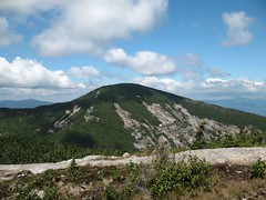
Santanoni and Panther peaks

The weather forecast called for 30% chance of showers which in the Santanoni range means a 100% guarentee. About half of the approach trail is flat with no drainage and is legendary for its mud pits. I was apprehensive about this hike based on all the horrific things I had read about it but in fact I really enjoyed it. The approach trails are mostly flat and the mud pits were plentiful but not too bad. I only went in up to my knee one time! I enjoyed ascending the Panther brook herd path which was quite scenic and not as hard as I was expecting although it did have its moments. The herd paths on the Santanoni ridge were easy to follow but the vegetation was grown in ono the paths. On a rainy day this ensures that you get the maximum possible soaking. It is a 10 minute walk over to Panther peak which on a sunny day would have a nice view from it's somewhat open summit. On this day all I got was the inside of a cloud. Return to Herald square where a left turn led to Times Square and then another left led to Santanoni peak. For the return trip I took the newly opened and not yet named New-Old Santanoni trail. It drops precipitously off the ridge which made for some fun given the wet conditions and the brush that obscures your view of your feet. Nonetheless, it shaves about a mile or two of the return to the parking lot at Upper Works. I'm not sure I would want to hike up this trail but it sure does the trick coming down. I have to return at some point for "Couchie", perhaps on a dry day next June!
Panther peak summit marker Santanoni peak summit sign

Saturday 11 August 2007

Rocky Peak Ridge

Rocky Peak Ridge from Giant

Giant is one of those mountains that draws a crowd. It is "only" 3 miles from the road to the top. It is however an elevation gain of 3000ft. A lot of the climb is on open rock so when you stop for a rest you get to enjoy the view which keeps getting better the higher you go. About a quarter mile before the top you reach the 1.1 mile trail to Rocky Peak Ridge which descends sharply about 800 ft to a col and then rises on a more gentle grade for 500 ft to Rocky Peak Ridge.

The reward for this effort (beside check another of the list) is a larger and open summit with a lot less people and the same view with the addition of Giant up close. For most of the time I was there it was just me and a couple who were traversing along the ridge to another road where they had left a second car. As I made my way back to Giant I passed a steady stream of hikers complaining about the crowds atop Giant. Ironically when I got back to Giant there were only two others there!

The walk down seemed to take forever and for sure it took longer than the hike up. As a reward there is a beautiful pond across the road where one can take a swim or at least cool off sore and acheing feet. All in all, a great day.

Giant's washbowl Dix range Giant from Rocky Peak Ridge Great range from Rocky Peak Ridge

Sunday 5 August 2007

Marshall, Marshall, Marshall

Iroquois from the Mt Marshall herd path

Ah, success at last! Armed with some good karma from the Cat Power cds that I was listening to on the drive down, I met up with Mark and Louis who were staying at the LOJ for the weekend. They were going to Cascade so I decided I would rather have another go at Mt Marshall. The route was the same one I had planned with Ken (hopefully recovered soon). The trail up Cold Brook Pass was quite rough and eroded. The herd path to Mt Marshall was well marked with a cairn and it was (as all of them are) a delight. Easy to follow, mostly soft underfoot, a bit grown-over in places and some fun little rock scrambles too.

Marshall summit sign
I had seen few people all morning but within ten minutes of reaching the top, three groups showed up. It became a 33 convention as for several of us this was 33 on the list of 46. Most were headed down the way I was going but one group were off to bushwack up to Iroquois and then out via Algonquin. They suggested I join up but I thought better of it.

The walk out was a long and tiring trudge down the Herbert Brook herd path then past Lake Colden and Avalanche Pass. Along the way I mistakenly got on the wrong trail and started back up towards Cold Brook Path before realising my mistake and doubling back to make sure I was going the right way. While Lake Colden and Avalanche Pass are scenic as heck the going is slow and rocky underfoot. That said, I scoped out some scenic leantos that would be great to stay at. I made it back to the car at around 7:30 after setting out at 9. A long day but well worth the effort.

View of lake colden from cedar point lean to  Hitch-up mathilda along Avalanche lake
Marcy Dam  Sunset on Heart Lake