Whiteface was one of my first Adirondack high peak hikes, Mark and I hiked up from the Atmospheric station several years ago. That trail starts with a relentless climb up Marble mountain. Friday's hike from the Connery Pond trailhead was the inverse. The first 3+ miles gain little elevation and are generally soft underfoot. It is a pleasant "walk in the park" to that point. The trail makes a big right turn at Whiteface Landing (a small dock on the shore of Lake Placid) and heads up the side of a brook until reaching a lean-to. At Whiteface Landing you pass a sign that indicates 3 miles to the summit and 2932 feet to gain (yikes!!). The section between the landing and the lean to is not too bad and is still soft.

From the lean-to on, the party is over. From that point on it is steep and rocky (and nasty) with no let up. Thankfully it was almost completely dry. I'm pretty sure that the trees, rocks and whatever wildlife lives up there hear plenty of cussing and complaining from hikers on their way up (probably down too). Most of the ascent is in the woods which at least gives you some protection from the sun as well as trees to use to pull yourself up the steeper bits. Just as you are about to throw in the towel and call for a helicopter the trail breaks tree line and you start to see some views. There are some fun short scrambles and thankfully the rock wall above is the summit.
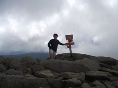
The summit is a somewhat strange experience. You haul your sorry self over that last rock and think to yourself "Hey, where did all these people come from and how come none of them have backpacks? And who ever heard of families with small kids hiking up a mountain in flip-flops?". Whiteface, has an
auto-road to the top. In the summer you can pay to drive up (and in the winter you can
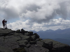
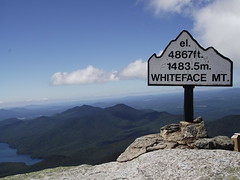
xc ski up). It would be a great bike ride, although you would need to check your breaks beforehand! For those that make the drive there is the option of hiking the last few hundred feet with a railing to hold onto or taking the small elevator. There is a restaurant as well as a small gift shop and those binocular things you put a quarter in. While the masses seemed to be enjoying the summit, I bet they secretly wished they were hot, exhausted, sweaty and not quite sure they were going to make it back down to their cars like me! The view from Whiteface is quite something and especially on a clear sunny (not hazy) day and there is plenty of space to find a spot and soak in the view.
The return trip was slow going. I met a few groups on their way up. A short nap at the lean-to was a welcome rest stop. Just as I was nearing the parking lot I could hear someone crying. At first I thought it was my sore feet voicing their displeasure but it turned out it was a family setting out on a walk that one of them was not happy about. I don't know what he/she was complaining about, being carried in a backpack and all!
More photos.
Labels: Adirondacks, Connery Pond, hiking, Whiteface