Tuesday 30 September 2008

Pink Lake loop

IMG_4834

red-gat-parkway
On Monday I went for a drive on the parkways in Gatineau Park to check out the leaves. A recent cold snap has caused the colors to change quickly. While they were plenty red, orange, yellow etc they were not at peak. I hit both lookouts (Huron and Champlain), stopped the car many times to snap a shot of colorful trees lining the road (it was early and there was no traffic) and pulled over at each and any vista point such as small beaver ponds or swamps.

pink-lake-colors3
On the way back to town I stopped in at Pink Lake and walked the loop. This is a great little walk at any time of the year and especially when the leaves are changing. There was even more boardwalks and staircases that the last time I was there as erosion of the steep shores is a problem. Not only were the leaves looking great but there was a constant sound of geese flying overhead on their way south.

The colors are not at their peak but should be there in a weeks time.

IMG_4805

skyline-ridge-colors

can-geese-2

water-leaf

Labels: , , ,

Saturday 13 September 2008

Down in the hole

IMG_3935

IMG_3934
After hiking a glorious peak last Wednesday, Bryan and I decided to visit a local landmark in Gatineau Park. I had never been in Lusk Cave even though I have hiked, biked and skied past it many times. Too bad because it is a ton of fun. I think we picked a good time to visit as the water flowing through the cave was warm and the water level was reasonable.

IMG_3927
You need a minimum of spelunking equipment (headlamp, water shoes, bathing suit) and a sense of adventure. For the most part the ceiling was quite high with the exception of the exit from the first half and the final exit from the cave where you had to bend over to move forward in the thigh deep water. The surface was not slippery and there were handholds where needed. It took us about an hour to go from one end to the other but that was mostly due to posing for photos. When combined with the hike from the parking lot and a swim at one of several nearby beaches, Lusk Cave makes for a great day out in Gatineau Park.

IMG_3885 IMG_3888
IMG_3956

Labels: , , ,

Wednesday 10 September 2008

Best hiking day...ever

IMG_4547

IMG_4732
I've been known to throw around superlatives when it comes to various hikes (often the hike I am currently on). That said, Algonquin is my favorite mountain of any that I have hiked and Wednesday was about as perfect a weather day as one can get. It was cool (low 60s), sunny and crystal clear. A day made for hiking peaks and taking photos! I managed to talk Bryan out of going to work and joining me on a hike up Algonquin Peak instead. It is a long drive from Ottawa to the Adirondacks to day hike but the advantage is that you can cherry pick the weather.

IMG_4699
We were approaching the border when we saw that there was a mass of clouds blanketing the Adirondacks. Luckily it was early and soon to burn off. We took some cool photos in the early morning light and stopped for break in Saranac Lake to fuel up and to sit at a favorite spot.

IMG_4602
We hit the VanHo trail at about 8:45 from a mostly empty parking lot. The hike starts out a comfortable pace and is mostly flat for the first mile. It gets gradually steeper and rockier as it ascends. It is only a four mile hike but you do have to watch where you step on and around the rocks. We stopped at the waterfall which marks the half way point and were passed by the first of several hikers with dogs for the day. All were well behaved and gave us the opportunity to chat up their owners.

IMG_4574
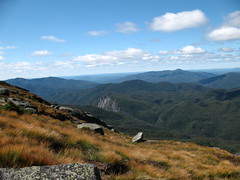
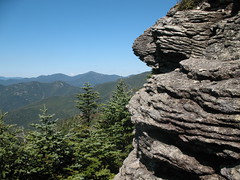
Past the cutoff to Wright there are some interesting steep slabs and once you get above Wright you start to get views to the east of Pitchoff, Cascade, Porter, Big Slide and eventually the Great Range. You really see the the full effect of Big Slide from this angle. Our pace slowed as we were taking lots of photos and videos. Above treeline the summit grass were a particularly colorful shade of gold and the views in all directions were crystal clear. I particularly enjoyed getting photos of the Santanoni and Seward ranges that I had hiked since the last time I hiked Algonquin.

IMG_4633
We stayed on the summit for almost two hours and for such a perfect day there were not many people up there so it was nice and quiet. We took even more photos on the way down, at least until we hit tree line. It was great to stop at the falls and dunks our heads in the cool water. We met a few hikers on the way oot (out as pronounced by Canadians eh). One from the Buffalo area identified us as Canucks based on our accents. We talked photography for a while before he took off back to the LOJ as he was late for dinner.

A perfect day hiking Algonquin. It may take as long as the hike to go through all the photos!

IMG_4756

Labels: ,

Wednesday 3 September 2008

Hough via Lillian Brook

houghsummit

elklakefromhough
It was overflow parking in the Elk Lake parking lot when I went to check it out on Sunday afternoon. I got there early on Monday morning to make sure there was a spot and was happy to find plenty of room. I was the first to sign in the log book that day and one of only four groups to sign in all day. The Elk Lake-Dix trail is somewhat rocky, a little bit muddy but generally is flat and takes you past two lean-tos and the herd paths to Macomb (Slide Brook) and South Dix-Hough (Lillian Brook). My goal for the day was to head up the Lillian Brook trail and follow it up to the ridge on the Dix range between Pough (bump on ridge between South Dix and Hough) and Hough.

skylightmarcyfromhough
The Lillian Brook trail was yet another example of trailwork by the 46ers. Each time I hike another trailless peak I gain more respect for the work they do. This trail had a reputation of being full of blowdown and a place one could easily get lost. It started out a bit swampy but after a hundred yards or so it was dry and it ascended at a gentle grade through a fairly open forest until at 3200 feet there was a split with the right fork leading to the col between Macomb and South Dix and the left fork leading to the col between South Dix and Hough. The grade immediately steepened considerably and stayed steep for the next 800 feet. Hard work to be sure. Once up on the ridge it was a steep but fairly short climb up to Hough summit with some short rocky scrambling near the top. There were two good viewing ledges with views of Dix and many of the high peaks to the north. Dix looks especially striking from this angle with a very pointy top almost like a narrow volcano cone. It was a clear sunny day with a stiff breeze to stay cool and it was an awesome spot to sit and gaze.

dixfromhough
I debated heading back over South Dix to East Dix and then back down but I decided that I would leave East Dix until another day as it would make a good candidate for a peak to finish the 46 on. Also my toe was acting up again. This was a great dayhike with a return trip of about 12 miles on nice trails with an elevation gain of approximately 2400 feet and a sweet view from the summit.

Again, well done 46ers on maintaining the excellant Lillian Brook trail!

Panorama from Hough

Labels: , ,

A scenic ride down Rte 73

pitchoffrte73

On the way to many high peak trailheads (Cascade, Pitchoff, Marcy Field, Ausable Club, The Garden, Roaring Brook, Giant Ridge, Round Pond) you have to follow the stretch of Rte 73 from Rte 86 in Lake Placid to the Northway. There are many great viewpoints along this road but one is usually in too much of a hurry to stop and appreciate the sights on the way to the trailhead and too looking forward to a post hike beer at a pub after the hike.

Enjoy the sights!

macintyrerange cascadelakes73

keenerte73 rangerte73

noonmarkrte73 roostercombrte73

Labels: ,