Sunday 19 October 2008

Colvin

IMG_9307
After our lengthy stay at Indian Head-Fishhawk Cliffs, we left at about 12:45 and started up Colvin. There would be no Blake on this day due to time and daylight but Bryan wanted to add another 46er to his list and Colvin has a nice view. I had been to Colvin-Blake before on a hike with the Albany ADK chapter but we did not spend a lot of time at the summit. This is a typical Adirondack hike with mud, roots and rocky ascent up slippery slabs with some fun steep scrambles and at least two false summits. It was a welcome bonus that the cold temperatures made the mud pits solid so one could walk right across them.

IMG_5600
It seemed that everyone we met was going the other way and it was getting colder as we went up. Regardless we spent about 15 minutes up there snapping pics in all directions and hopping around to keep warm. I related to Bryan that it was too bad that we would not be able to head over to Blake as the autumn colors would have been awesome!! It was past three already and daylight was becoming a factor so we headed out. The Gill Brook trail is a real nice trail lower down as it passes many nice flumes and pools that one could stop at to cool down on a warmer day. As always the Lake Road is a brutal slog, to put it nicely, that punishes ones feet that have already taken a beating. Bryan tried walking in the leaves at the side of the road but I doubt it made any difference. We kept hoping the bus would come by and give us a ride but no such luck. The last two miles were in the dark but the road is wide enough that you don't really need to see where you are going. There were plenty of stars in the sky as we walked past the golf course to the parking lot.

A nice full day to cap off the hiking season....let it snow!


IMG_5583

IMG_5585

IMG_5409

IMG_5571

IMG_9348

Labels: , , ,

Indian Head and Fishhawk Cliffs

IMG_5539 IMG_5465

IMG_5312
Bryan and I wanted to get one last Adirondack hike in before it snows for good there. He wanted to up his total of 46er peaks while I just wanted to take in the remaining folliage from a good viewing area. We settled on hiking to Indian Head and Fishhawk Cliffs and then if time allowed after the requisite photoshoot we would continue on to Colvin. We arrived at the trailhead later than we wanted due to a few stops for must see photo-ops at Barnum Pond (mist on the water) and LOJ road (frosty grass).

IMG_5483
It was colder walking along the LOJ road that I had thought and there were tons of leaves falling from the trees and lying on the ground. We took the Gill Brook bypass trail and there were even more leaves covering that trail. After a short hike we stepped out on Indian Head and had it ourselves for about twenty minutes. A spectacular view for sure even though most of the color was gone leaving a frosty white shade where the color had been and patches of yellows and oranges here and there.

IMG_5557
We took many photos of the various views: Gothics and the lower range, Colvin, Lower Ausable lake. This is a great spot to sit and have lunch. After soaking in all we could we head off to Fishhawk cliffs. This is a short walk that starts with a real steep drop off. This viewpoint shows you the profile of the Indian face and makes for some great photos of this profile with the great range in the background.

This a great hike that you can do in half a day and can be combined with a visit to Rainbow Falls and a leisurely stroll down the East or West River trails.

IMG_5366

IMG_5461

IMG_5539

IMG_5536

Labels: , , , , , ,

Monday 6 October 2008

Dix from rte 73

IMG_5153
Yesterday I hiked Dix from the Round Pond trailhead with Ken and Pete. The day started out badly as I had a nasty headache and a quick stop at the LOJ road showed that Algonquin, Colden and Marcy were each wearing a covering of snow on their summit cones. Regardless, this was to be Ken's 46th high peak so we were not gonna let a little snow stop us Canadians.

IMG_5098
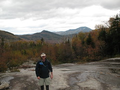
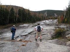
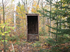
This is a really nice hike on a trail that is maintained by the 46ers, some of whom were out cleaning waterbars and chopping up some blowdown (Thanks!). The first stop along the way is Round Pond which looked great in the early morning with fall colors reflecting in water. The trail is mostly soft underfoot and at a gentle grade until you reach the slide that is past the Boquet river leanto. The slide provides a great spot for a break with views of a couple of slides, of Noonmark, Giant and RPR and plenty of autumn colors.

IMG_5144
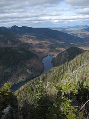
Beyond the slide the real ascent begins and it does live up to the guide books that describe the trail at this point as "murderously steep". It was steep but as Ken pointed out, you don't get as tired because the pitch means that you move more slowly. At this point the temperatures were dropping but at the same point we started to get views of Nippletop and the Great Range. We also started to see snow on the sides of the trail and in the trees. As we topped out on the ridgeline there was a spectacular sight of Elk Lake surrounded by fall colors.

IMG_5217
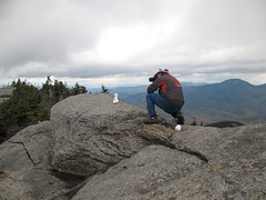
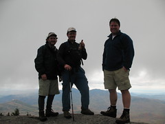
Onto the summit itself, where Ken was presented with a 46er...ale and congratulations were offered. Lunch was eaten, photos were taken, snowmen were assembled and photographed. This is a great peak with spectacular views but the cloud cover was at approx 5000 feet so the light was not perfect for photography. It was too cold to stay up there for long. The murderously steep section was slow but in general I found the grade of the trail and the colors in the trees to make for a pleasant walk out.

A great day to be out and celebrating Ken's accomplishment!

IMG_5215

IMG_5200

IMG_5120

IMG_5197

IMG_5199

Labels: , , , , , ,

A new 46er

IMG_5197

Yesterday I hiked Dix from rte 73 with Ken and his friend Pete. This hike completed the 46 for Ken and it was great to be with him on this hike. We have hiked to 14 of the high peaks over the last few seasons.
Ken is a great hiking buddy:

  • happy to slow down his pace to the slow poke in the group (me),

  • pretends to be tired too when you need to stop for a break,

  • full of insightful commentary on the surrounding peaks

  • and generally quick to dig a cold beer out the back of his truck after a hike


We enjoyed a cool 46er ale on the summit to toast the occasion. Congrats Ken!

    Labels: , ,

    Friday 3 October 2008

    King Mountain

    king-mtn6

    king-mtn7
    This is another nice short hike in Gatineau Park that has plenty of bang for your buck. The parking area is off the Champlain Parkway about halfway up to Champlain Lookout. It is a loop of about a mile with a climb of about 200-300 feet from the parking to the top of a ridge. As you make your way along the ridge there are open ledges looking south across the Ottawa River valley, the lower section of Gatineau Park and the cities of Gatineau and Ottawa. Along the trail are signs that explain the various types of trees and why they grow where they do.

    king-mtn2
    The payoff today was the glorious colors in the trees, especially in the forest below the ridge, and the wide open viewpoints to see them from. I sat for a while on one of the benches and soaked in the oranges, reds and yellows as far as the eye could see. I managed to time it just right as I returned to the car there was a loud group of school children that sounded like a herd of cattle as they headed out.

    Colors seem pretty close to peak.


    king-mtn4

    king-mtn1

    king-mtn8

    king-mtn5

    Labels: , , ,