Tuesday 29 March 2011

Tom ain't so bad after all

Grey jay on Mt Tom

Grey jay on Mt Tom with Presidential range backdrop
Six years ago in June Mark, Munch and I were doing a 6 day hut to hut hike from Pinkham Notch to Greenleaf (highly recommended). On day 3 it was raining as we took the scenic route from Mizpah to Zealand Falls, diverting to go over Mt Jackson (a 4000 footer) instead of taking the gently sloped Crawford Path. We were pretty sore when we exited the woods at Crawford Notch after slip sliding down a rough trail with at least one of us sporting a bruise that swelled up like an egg. We were wet, muddy, sore and not exactly happy. What had looked like an easy day was anything but and the 2000 foot climb out of the notch to the Willey range was a butt kicker. When we reached the range there was a sign saying "spur trail to Mt Tom". A quick stop to ask "Should we?" followed by some muttered curses and "no $#@@ing way" before we continued on our way to the hut (which drops down on the range before going up a steep hill to Zealand Falls hut. It was a nasty day that was only saved by the hut which is in a sweet location and has a nearby waterfall, it is a great place to stay.

On Mt Tom with Presidential range backdrop
Well, I returned to the scene of the crime while on a ski trip to Gorham. It turns out that Mt Tom has some sweet views of the southern presidentials and Mts Washington and Jefferson (in the winter at least) and of a variety of peaks like Carrigain and the Twins from the actual summit. There is also a local group of grey jays that will eat out of your hand (and will give you the stink eye if you don't opt to share your spicy italian sub with them). The hike up from the Highland center is steep but not overly so and uses switchbacks in the steepest parts. The spur trail is pretty short and mostly flat. The butt sliding is quite good on the way down although on the side hill sections it tends to steer you to the downhill side so you have to watch where you are going.

I guess what I am saying is Mt Tom is worth a visit, especially in the winter and makes a nice loop with Mt Field and Avalon. Bring some food for the birds and a butt sled!

Labels: , , ,

Thursday 17 March 2011

All's right on Wright

Colden and MacIntyres from LOJ road

Wright trail junction
After hiking Colden, the weather was forecast to be even better. I opted for Wright Peak as it had a similar elevation gain but a much shorter hike. My legs were tired and sore and I had some semi blisters on my feet but a bluebird day is too good to miss. Again there were few cars in the lot for such a nice day. The first mile is flat but from then on it just goes steadily up without stopping. From summer hikes I remember this trail as quite rocky with awkward footing. Today it was nice and flat. As with yesterday's hike it was plenty of stops to get some oxygen and keep the pulse rate at bay. There were several brook crossings and a quick stop at the waterfall that is currently all thick ice. The first views start with the Seward range off to the right and Whiteface if you turn around.

Alpine environment on Wright
I was expecting to see a 3500 feet sign and was getting worried that I was hiking slower than I thought when I arrived at the trail split to Wright. None too soon as I had thought that the white summit I could see above was Wright when in fact it was Algonquin!! The Wright trail had that nice winter look to it with trees coated in white stuff and there are views in all directions as you stop and look around. This was the first peak with a rocky summit that I have hiked in winter and I realise I will have to invest in some crampons as the snowshoes aren't really up to the job. Lucky this day though as there was no wind to speak of and hardly a cloud in the sky either. My only complaint was that if I had been quicker on the ascent the sun would have been behind for photos towards Colden and Marcy. But no complaints about a beautiful day with a peak to myself. I spent about an hour snacking and snapping photos and making a mental note to put some sunscreen in my pack in the future.

Cloud blowing over Algonquin
As I made it back to treeline the afternoon shift arrived in the person of a guy from Vermont. Yesterday's butt sliding lessons were put to work on the return to the Algonquin trail. This would be a great hike to have a sliding device. As it was I was able to slide down most of the Wright trail below tree line and many big sections of the trail back to the LOJ from there. On the way down I met four groups going up. Two of the groups were heading up Wright armed with skis. The highlight of this hike is the views in all directions from the rocky summit but the sliding on the way down is a close second!

More pics here

Labels: , , ,

Wednesday 16 March 2011

Winter wonderland on Colden

Big Slide from trail on Colden

On Colden with MacIntyre range behind
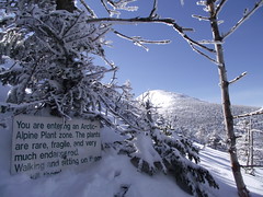
I enjoyed last year's March vacation that I decided to do it again this year. What's not to enjoy about spring skiing and winter hiking in generally sunny and warmish temperatures. To kick off the holiday, Ken and I decided on a hike up Mt Colden via the Lake Arnold trail. It is a 6.5 mile hike that starts out mostly flat, until you reach Avalanche Camp that is. Thereafter it more than makes up the difference with a constant uphill grade that gets steeper as you get higher up. If you have read any of my previous reports from last summer you would know that this is my fourth time up the Lake Arnold trail since last June. While I almost know every boulder by name you could not see any of them now as they are buried under a generous snowpack that forms a well packed sidewalk (tilted for sure but a flat surface).

Lake Arnold tentsite privy
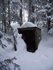
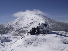
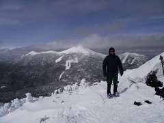
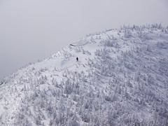
I haven't been out that much this winter and the inactivity made itself apparent as soon as we started uphill. Numerous stops (without the usual excuse of taking photos) to keep the pulse rate down got us to Lake Arnold and the junction with the trail to Colden. We stopped for a snack and went to investigate the tent site and found a privy that was half buried in snow, when you gotta go .... This section of trail was less packed and definitely steeper but also beautiful with snow and rime covered trees all around and many trail disks at knee level or below. We made it to the north summit with its beautiful view in all directions and marshmallow trees. I decided that the view from there was just fine and that was as far as I was going to go. Ken headed off to the actual summit which is about a half mile and several hundred feet higher.

Lone hiker descending Colden's summit
This worked out well as we were able to take some nice photos across the gap between the peaks. I also appreciated a bit of quiet time as monday was the funeral of a 
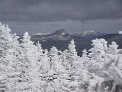
friend of mine in Scotland who died too young. These mountain are a great place to reflect and get a little healing of the soul. The clouds were hanging at about 5000 feet and so we could not see the top of Marcy and Algonquin was drifting in and out of the clouds most of the time we were up there.

The descent was much easier. Ken had brought a red mini sled that added jet fuel to the manouver referred to as the glissade or butt slide. All the steep bits that we huffed and puffed up slid by in a flash and even the walking down hill went by fast. You can slide down on snow pants but I think the red rocket is the way to go. The last three miles of the hike was a bit of a trudge and I could feel blisters starting to form and muscles starting to tighten. No complaints though, it was another awesome day out in the high peaks.

More pics here

Labels: , ,