Tuesday 26 June 2007

Franconia ridge

mark and lincoln

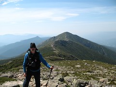
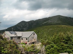
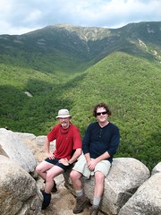
We had been looking forward to this hike for a long time and were treated to a great weather day. The hut crew at Greenleaf did their usual breakfast weather report that mentioned a chance of t-storms (I think they say that every morning) and how to avoid being struck if one should occur. Well it was sunny all day and about 80F. It is about a mile up to Lafayette from the hut and 1000 ft in elevation gain. From there on it was all about views and taking hundreds of photos. The ridge runs about 2 miles from Lafayette to Little Haystack and goes over several small bumps as well as Lincoln along the way.


me on lafayette

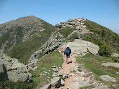
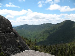
The views go for miles in all directions from the Kinsman ridge and Mt Cannon to the west to the Pemi wilderness and Bonds to the east but the best views are in either direction of the ridge itself. What a great day for sure. There was soup served back at the hut with dinner but it was not as good as the "best bowl of soup ever" from 3 years ago.

Monday 25 June 2007

Return to Greenleaf Hut

greenleafhut
Last time I visited Greenleaf Hut was in June 2004 and it was the last of a hut to hut traverse with Mark and Mike. It was a very tough hike to get there from Galehead that left many in our group exhausted and had me proclaiming that the staff had produced the best soup I ever tasted (I needed some nutrients!). Mark and I returned to Greenleaf for a short trip that would include hiking the Franconia Ridge and then two days later, the Bonds.

bridle path view

We hiked up the Old Bridle Path, the trail we descended on last time. Three years ago it had been overcast and foggy and we saw no views. This time we stopped on one of the lookouts and were treated to an awesome view of Lafayette and Lincoln. A great spot to sit for a while. It was a short hike from there up to the hut. As an added bonus the hut was close to empty and we had a huge bunkroom to ourselves (plenty of buffer space from snorers!).


After dinner we went to nearby Sunset rock, to take some photos.


greenleafsunset

Sunday 10 June 2007

Seymour


SewardRangefromSeymour
It was time to get out hiking in the Adirondacks again. The weather is warm, the snow almost completely gone and the bugs well yes they decided it was time to get out too. To continue the assault on the 46 (46 peaks over 4000ft in the Adirondacks), Ken and I settled on Seymour mountain in the Sewards. One of the advantages to hiking the Sewards is that they are the closest to Ottawa at just about 2 1/2 hours drive. This means a little more beauty sleep before driving down for the day. We left at 6 and were at the trailhead at the end of Corey's road at about 8:30, checking packs and applying bug juice etc. We signed in at the trailhead and there were only two other parties with Seymour as their destination. And as it turned out we only saw two other groups all day.


This hike involves a long flat walk 0f about 5 miles through the woods: across a few brooks, past two lean-tos and past more than 50 signs advertising the bordering Ampersand Club property (and that one should not trespass there). We finished this section of the hike in about 2 hours and that was where the fun began. The rest of the trail to the summit was a herd path which is an unmarked path through the woods. Most of the herd paths in the Adirondacks are maintained by the 46ers and are an absolute pleasure to walk on. This one was no different. The first part of it was at a steady grade through the forest and soft under foot. After about a mile or so it started a very steep climb up wet and muddy rocks slabs. When we reached the top it was well worth it as there were stellar views of the Seward range from a small ledge where we ate lunch as well as a great view of the Santanoni range from just past the summit. It was a tricky descent and then a long trudge out to the car. All told a great hike.